Enregistrez gratuitement cette image
en 800 pixels pour usage maquette
(click droit, Enregistrer l'image sous...)
|
|
Réf : T01845
Thème :
Terre vue de l'espace - Villes (375 images)
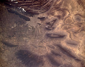
Titre : Monterrey, Mexico March 1994
Description : (La description de cette image n'existe qu'en anglais)
Monterrey, capital of Nuevo Leon and Mexico’s third largest city (with an estimated 1990 population of 2.5 million), has long been the country’s leading industrial center and the principal railroad hub for northeast Mexico. Power line rights-of-way, railroads, and highways can be seen in this near-vertical photograph. Field patterns are visible in the broad valleys east of metropolitan Monterrey. The north-south-trending, folded Sierra Madre Oriental Mountain Range is a series of elongated limestone ranges forming the eastern rim of the elevated Mexican Plateau. The mountains play a key role in Monterrey’s environment; for example, severe air pollution problems can develop when air stagnation occurs. Ridges in this mountain range vary from 7000 to 8000 feet (2000 to 2400 meters) in elevation, with some peaks reaching 13 000 feet (4000 meters). The ridges and valleys are the result of geologic folding of bedrock and are similar to the folded Appalachian Mountains of the eastern United States. The Sierra Madre Oriental Range veers westward west of Monterrey, forming an anticlinorium, a spectacular series of folded ridges and valleys. The mountains become more fragmented and eroded north and east of the city.
|
|

